


وصف لـ Map Pad GPS Land Surveys & Measurements
Use MapPad to calculate areas, perimeters and distances - save, export and share your measurements.
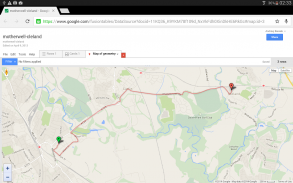
MapPad is providing multi-purpose mapping solution allowing location capture and determines distance and area for the shapes drawn on the map or captured using real-time GPS tracking.
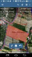
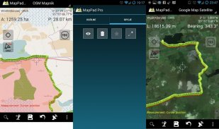
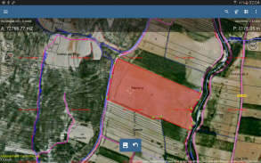
Calculate area of the field or a walk distance instantly using Google or Bing Map Satellite view. Save petrol and time and capture features with few clicks on the map.
Area & Distance measurements are very accurate - please compare with other apps and what's on the ground.
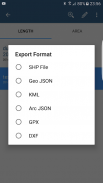
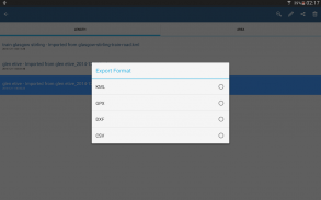
With MapPad you can capture, manage and share your data easily. App supports number of well-known cloud providers like G-Drive, Dropbox and export formats: SHP File, GeoJSON, ArcJSON, KML, GPX, CSV and AutoCAD DXF.
MapPad is a very useful tool for anyone involved in forestry, agriculture (measuring farms, soils, grow, check planted area etc.), roofing, solar panel planning and solar panel installation, fencing, construction, real estate management, asset management, winter snow removal or farming business.
MapPad also can be used in the whole range of outdoor activities like golf (distance meter and range finder), biking, walking, running, jogging and other sports where possibility of measure areas or distances is necessary.
Please visit our website to find out how to prepare offline map and get more information about this product.
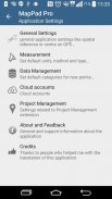
Selected features:
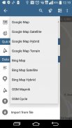
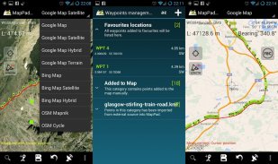
- Base maps: Google Maps (Standard, Satellite, Hybrid, Terrain), Open Street Map (Mapnik, Cycle), Bing Maps (Satellite, Hybrid, Roads).
- Google Maps Overlays (Custom WMS or ArcGIS Server Tiled service), some layers like US Topographic map have been predefined.
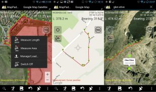
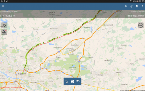
- Very accurate measurement of areas and distances.
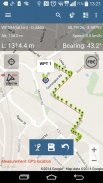
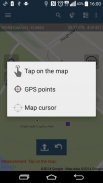
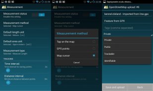
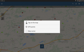
- 3 methods of measurement are supported (Tap on the map, GPS location, Map cursor location).
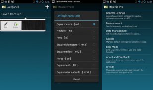
- Support for number of metric and imperial units.
- Support for several global and local coordinate systems: WGS84 (decimal or degrees), Web Mercator, British National Grid, UTM SAD69 (Brazil), UTM NAD83, NATO, Stereo70 (Romania), System 1992 (Poland), Greek Grid – if you require support for any other spatial reference please get in touch.
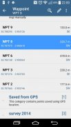
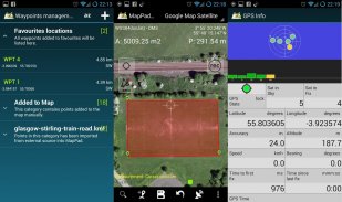
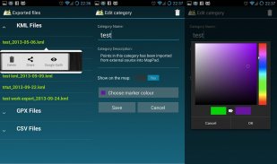
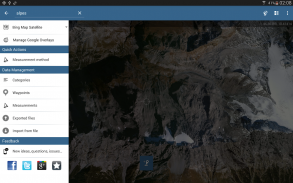
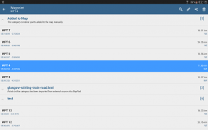
- Possibility to capture waypoints and group them in categories.
- Possibility to add\edit title and description for each recorded measurement and waypoint.
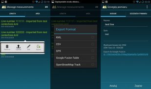
- Export single or multiple measurements or waypoints to SHP File, GeoJSON, ArcJSON, KML, GPX, CSV and DXF to SD Card or cloud services like Fusion Tables, Dropbox or Directly to Open Street Map.
- Share single waypoint location directly by SMS, E-mail or other ways.
- Elevation profile available for measurements done by GPS.
- Import of KML and GPX files to the application.
- GPS status and satellites status.
- Address, location search.
- Quick open exported KML files in Google Earth
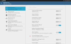
- Ability to set default measurement units, waypoints' categories colours, track recording time and distance interval, transparency of Google Maps overlays and much more...
Please note:
If you experience any problems or have new ideas or comments please do not hesitate to contact us directly or using the contact forms provided on our website. We take your opinion very seriously and do appreciate any form of feedback.
Our users are successfully using MapPad in number of applications including:
- environmental surveys,
- roofing and solar panel planning,
- calculations for snow removal,
- biking and walking routes planning,
- forestry planning and woodland management,
- agriculture and soils' surveys,
- road constructions,
- tree surveys
استخدام MapPad لحساب مناطق وأراضي والمسافات - حفظ وتصدير وتبادل القياسات الخاصة بك.
MapPad تقدم الحل رسم الخرائط متعددة الأغراض مما يتيح التقاط الموقع ويحدد المسافة والمساحة لالأشكال المرسومة على الخريطة أو القبض في الوقت الحقيقي باستخدام تتبع نظام تحديد المواقع.
حساب منطقة حقل أو على بعد مسافة سيرا على الفور باستخدام طريقة العرض جوجل أو بنج خريطة الأقمار الصناعية. حفظ البنزين والوقت والتقاط ملامح مع نقرات قليلة على الخريطة.
منطقة والمسافة قياسات دقيقة جدا - يرجى مقارنة مع تطبيقات أخرى وما هو على أرض الواقع.
مع MapPad يمكنك التقاط وإدارة وتبادل البيانات بسهولة. التطبيق يدعم عدد من مقدمي الخدمات السحابية المعروفة مثل G-درايف، دروببوإكس وصيغ التصدير: ملف SHP، GeoJSON أيضا، ArcJSON، KML، GPX، CSV وأوتوكاد DXF.
MapPad هو أداة مفيدة جدا للمتورطين في الغابات والزراعة (مزارع قياس، والتربة، وتنمو، والتحقق من المساحة المزروعة الخ)، والسقوف، والتخطيط لوحة للطاقة الشمسية وتركيب الألواح الشمسية، والمبارزة، والبناء، وإدارة العقارات، وإدارة الأصول، الشتاء إزالة الثلوج أو الأعمال التجارية الزراعية.
MapPad كما يمكن استخدامها في مجموعة كاملة من الأنشطة في الهواء الطلق مثل الجولف (مسافة متر ومكتشف المدى)، وركوب الدراجات، والمشي والجري والركض وغيرها من الألعاب الرياضية حيث إمكانية مجالات التدبير أو مسافات غير الضرورية.
يرجى زيارة موقعنا على الانترنت لمعرفة كيفية إعداد خريطة حاليا والحصول على مزيد من المعلومات حول هذا المنتج.
الميزات المحددة:
- خرائط قاعدة: خرائط جوجل (قياسي، الأقمار الصناعية، الهجين، اراضي)، توسيع خريطة الشارع (Mapnik، دورة)، بنج خرائط (الأقمار الصناعية، الهجين، الطرق).
- خرائط جوجل الأغطية (مخصص WMS أو نظام ArcGIS خدمة القرميد خادم)، تم معرفة مسبقا بعض الطبقات مثل خريطة طبوغرافية الولايات المتحدة.
- قياس دقيق جدا من المناطق والمسافات.
- يتم اعتماد 3 طرق القياس (الحنفية على الخريطة، الموقع GPS، خريطة المؤشر الموقع).
- تقديم الدعم لعدد من وحدات متري والامبريالية.
- تقديم الدعم لعدد من النظم العالمية والمحلية تنسيق: WGS84 (عشري أو درجة)، مركاتور ويب، الشبكة الوطنية البريطانية، UTM SAD69 (البرازيل)، UTM NAD83، حلف شمال الأطلسي، Stereo70 (رومانيا)، نظام 1992 (بولندا)، اليونانية الشبكة - إذا كنت بحاجة إلى دعم أي إشارة المكانية أخرى، يرجى الحصول على اتصال.
- إمكانية التقاط نقاط الطرق وتجميعها في فئات.
- إمكانية إضافة \ تحرير العنوان والوصف لكل قياس المسجلة وإحداثية.
- تصدير واحدة أو متعددة القياسات أو نقاط الطريق إلى SHP ملف، GeoJSON أيضا، ArcJSON، KML، GPX، CSV و DXF إلى خدمات بطاقة SD أو سحابة مثل الجداول الشاملة، دروببوإكس أو مباشرة إلى فتح شارع خريطة.
- حصة إحداثية واحدة الموقع مباشرة عن طريق الرسائل القصيرة أو البريد الإلكتروني أو وسائل أخرى.
- ملف تحديد الارتفاع متاحة للقياسات قام به GPS.
- استيراد KML وGPX الملفات إلى التطبيق.
- وضع نظام تحديد المواقع ووضع الأقمار الصناعية.
- العنوان والبحث عن المواقع.
- فتح سريع تصدير ملفات KML في برنامج Google Earth
- القدرة على تحديد وحدات القياس الافتراضية، نقاط الطريق "فئات الألوان، المسار تسجيل الوقت والمسافة الفاصلة، والشفافية في خرائط جوجل تراكب وأكثر من ذلك بكثير ...
يرجى الملاحظة:
إذا واجهت أي مشاكل أو لديك أفكار أو تعليقات جديدة لا تترددوا في الاتصال بنا مباشرة أو باستخدام أشكال الاتصال المقدمة على موقعنا. نحن نأخذ رأيك على محمل الجد وأقدر أي شكل من ردود الفعل.
مستخدمينا تستخدم بنجاح MapPad في عدد من التطبيقات بما في ذلك:
- مسوحات بيئية،
- السقف وتخطيط لوحة للطاقة الشمسية،
- حسابات لإزالة الثلوج،
- ركوب الدراجات والمشي تخطيط الطرق،
- تخطيط الغابات وإدارة الغابات،
- الزراعة ومسوحات التربة،
- الإنشاءات على الطرق،
- استطلاعات شجرة
Use MapPad to calculate areas, perimeters and distances - save, export and share your measurements.
MapPad is providing multi-purpose mapping solution allowing location capture and determines distance and area for the shapes drawn on the map or captured using real-time GPS tracking.
Calculate area of the field or a walk distance instantly using Google or Bing Map Satellite view. Save petrol and time and capture features with few clicks on the map.
Area & Distance measurements are very accurate - please compare with other apps and what's on the ground.
With MapPad you can capture, manage and share your data easily. App supports number of well-known cloud providers like G-Drive, Dropbox and export formats: SHP File, GeoJSON, ArcJSON, KML, GPX, CSV and AutoCAD DXF.
MapPad is a very useful tool for anyone involved in forestry, agriculture (measuring farms, soils, grow, check planted area etc.), roofing, solar panel planning and solar panel installation, fencing, construction, real estate management, asset management, winter snow removal or farming business.
MapPad also can be used in the whole range of outdoor activities like golf (distance meter and range finder), biking, walking, running, jogging and other sports where possibility of measure areas or distances is necessary.
Please visit our website to find out how to prepare offline map and get more information about this product.
Selected features:
- Base maps: Google Maps (Standard, Satellite, Hybrid, Terrain), Open Street Map (Mapnik, Cycle), Bing Maps (Satellite, Hybrid, Roads).
- Google Maps Overlays (Custom WMS or ArcGIS Server Tiled service), some layers like US Topographic map have been predefined.
- Very accurate measurement of areas and distances.
- 3 methods of measurement are supported (Tap on the map, GPS location, Map cursor location).
- Support for number of metric and imperial units.
- Support for several global and local coordinate systems: WGS84 (decimal or degrees), Web Mercator, British National Grid, UTM SAD69 (Brazil), UTM NAD83, NATO, Stereo70 (Romania), System 1992 (Poland), Greek Grid – if you require support for any other spatial reference please get in touch.
- Possibility to capture waypoints and group them in categories.
- Possibility to add\edit title and description for each recorded measurement and waypoint.
- Export single or multiple measurements or waypoints to SHP File, GeoJSON, ArcJSON, KML, GPX, CSV and DXF to SD Card or cloud services like Fusion Tables, Dropbox or Directly to Open Street Map.
- Share single waypoint location directly by SMS, E-mail or other ways.
- Elevation profile available for measurements done by GPS.
- Import of KML and GPX files to the application.
- GPS status and satellites status.
- Address, location search.
- Quick open exported KML files in Google Earth
- Ability to set default measurement units, waypoints' categories colours, track recording time and distance interval, transparency of Google Maps overlays and much more...
Please note:
If you experience any problems or have new ideas or comments please do not hesitate to contact us directly or using the contact forms provided on our website. We take your opinion very seriously and do appreciate any form of feedback.
Our users are successfully using MapPad in number of applications including:
- environmental surveys,
- roofing and solar panel planning,
- calculations for snow removal,
- biking and walking routes planning,
- forestry planning and woodland management,
- agriculture and soils' surveys,
- road constructions,
- tree surveys
Map Pad GPS Land Surveys & Measurements - إصدار 7.5.0
(19-05-2019)
Map Pad GPS Land Surveys & Measurements - معلومات APK
نُسخة APK: 7.5.0الحزمة: com.osedok.mappadتطبيقات من الفئة نفسها
قد يعجبك أيضًا...


